iFly EFB 14 With Satellite Imagery, Enhanced Charts, And Performance Upgrades
Adventure Pilot announced the release of version 14 of its popular Electronic Flight Bag, iFly EFB, delivering significant advancements in visual mapping, performance, and in-flight situational awareness.
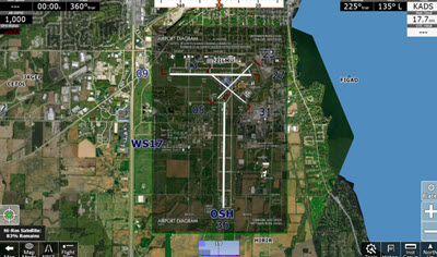
The new release introduces a new high-resolution satellite imagery layer, giving pilots an additional level of visual context for terrain, landmarks, and route planning. Combined with a new raster map layer and updated navigation charts, pilots now have access to clearer, more detailed map data across all phases of flight. “We focused this release on what pilots actually see and use in the cockpit,” said Juanita Boyd from Adventure Pilot. “Better visuals, faster performance, and clearer alerts—those are the things that make a real difference in flight.”
Key Highlights in Version 14:
- Satellite Imagery Layer: Pilots can now enable high-resolution satellite imagery directly within the map view, enhancing terrain awareness and visual navigation.
- New Raster Maps and Chart Improvements: A new raster layer delivers sharper charts with improved performance. Legacy WAC charts have been replaced with updated navigation charts designed for better readability at wider zoom levels.
- Graphics Engine Upgrade: A major upgrade to the underlying graphics engine improves rendering speed, responsiveness, and overall stability across devices.
- Enhanced Alerts with Audio Callouts: Expanded audio callouts now cover all major alert types, helping pilots stay informed without needing to look down during critical phases of flight.